To start, let's introduce the big ideas covered in chapter 1:
- Geography is the study of Earth. Geography is especially concerned with spatial location. That is, where things are, why they are there, how they got there, and how they interact with other things and other places.
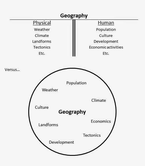
- Geography is typically taught at the introductory level with a divide between physical and human geography. This text will try to ignore much of that traditional divide by emphasizing when and how these systems interact.
- When we try to understand things we like to have effective ways of generalizing. Systems thinking helps us understand the relationships between things in a way
- Another effective way of generalizing in geography we use regions to simplify the complexity of what's really there.
- Geographers have several ways of describing place, including site, situation, and mathematical location; each of these useful in its own way.
- The combination of human culture and the natural environment creates numerous unique cultural landscapes. The formation of these landscapes is what I find most fascinating about geography and it is the central focus of this text.
 |
| NASA Blue Marble image of Earth. By NASA/ GSFC/ NOAA/ USGS [Public domain], via Wikimedia Commons |
1. Introduction: What is geography?
Stated simply, geography is the study of Earth. But lots of other disciplines study some part or another of Earth. So what sets geography apart from these other disciplines?Geography is principally concerned with space. Not space like outer space, but rather space like where things are located on Earth, and where they located are relative to other things. For this reason geography is sometimes called a 'spatial science' or 'geospatial science'.
One way to understand geography is to understand the type of questions that geographers ask and how that complements other disciplines.
For instance, historical geographers are not only concerned with the people and events of the past, they are also interested in questions like: How have landforms affected patterns of human settlement and influenced political boundaries?
 |
| Changing borders in northern Europe, 1805-1820. Screen capture from free version of Centennia Atlas, http://www.historicalatlas.com, (c) 2007 Frank Reed |
 |
| Fast food restaurants near Federal Way, Washington. Map data (c) 2014 Google |
2. A traditional divide: Human vs. Physical Geography
The two examples just given are both from what is considered human geography. Human geography is concerned with populations, their movements and migrations, their cultures and religions, and their economic activity.Geography's other major division is physical geography. It is concerned with Earth systems like the atmosphere, the oceans, landforms, and the like. This division is useful for compartmentalizing geography and focusing our study on one or the other. In fact, most college-level geography departments offer both an introductory human geography and an introductory physical geography course.However, it's my considered opinion that this traditional division takes a LOT away from what makes geography unique as a discipline. Geography's particular strength comes from the fact that it takes a holistic approach. That is, geography is a great tool for the study of Earth "concerned with complete systems rather than with individual parts." So this division of human vs. physical geography misses the fact that people live in places and depend on physical systems for life and economic activity, and that physical systems are being ever more affected by human activities.
This text follows some of the conventions of more traditional texts by having some chapters more focused on human geography and others more focused on physical geography. But I make a special emphasis wherever possible on how these systems interact with and influence one another (without being too deterministic about anything).
This discussion should make it clear that systems are an important part of geographic thinking. The next section describes and explains some important characteristics of systems.
3. Systems and Systems Thinking
Nearly anything you can think of is part of a system. Thinking about things as parts of systems (systems thinking) gives us a number of advantages over considering everything in isolation. First, it provides insight into the unit's function as part of the system. For example, insects may not seem important, or might even seem to be a nuisance, until their roles in feeding many other animals, decomposing dead organic matter, and pollination are considered. The same is true for the contribution of a small stream to a larger river and eventually the water cycle.Let's look at a generic diagram for a very basic system:
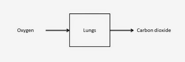
This is a little abstract but we can see that there are things that go into systems and things that come out of them. Here are some more concrete examples:
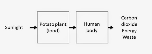
Clearly, lungs are part of a larger system (the human body)--but their basic function is to take in oxygen and exchange it with our blood, then exhale carbon dioxide. What would happen if the input of oxygen was stopped? First, carbon dioxide would no longer be output. But there are more serious ramifications for the function of other system components! We can diagram this larger system like so:
Earth systems can be diagrammed in the same way. Let's add a simple connection to the human system to understand how we fit into larger life systems:
Now we can see that sunlight is an essential input (among others) to creating food, which is essential to providing our bodies with energy. Waste products are also created as we metabolize our food.
Causation and System Feedback
Feedback is an essential part of systems--without it, systems would not function at all. Feedback describes the "signal" that a unit of a system receives from other parts of the system, and can be positive or negative.Let's take a look at some simple diagrams to understand relationships in systems. First, the arrows in the diagrams above have been showing the flow of inputs and outputs, short for "goes into" and "comes out of." We're going to ad a + or - sign to these arrows, which is a short hand way of saying "increases" or "decreases." For example, to return to the system of our human body,
The plus sign indicates a positive relationship that we have all experienced. We can read this two ways: "increased exercise leads to increased body temperature," or also "decreased exercise leads to decreased body temperature." Either way the relationship is positive, as more of one thing leads to more of the other and vice-versa.
Fortunately our bodies have a way of responding to increased temperatures, diagrammed below:
When our body temperature rises, we perspire (sweat) in response. The plus sign between body temperature and perspiration indicates that normally when body temperature increases, perspiration increases, and when body temperature decreases, so does perspiration. This is another positive relationship. Following the entire chain, we can see that more exercise leads to more perspiration.
Perspiration cools our bodies through evaporation. That's shown with the - sign, which can be interpreted as "increased perspiration decreases body temperature." The negative sign indicates a negative relationship-more of one thing is associated with less of another.
The lower arrow returning from perspiration to body temperature is an example of a feedback loop because it returns to an earlier part of the system chain. Feedback is essential to the functioning of systems and it's hard for us to understand how systems work without understanding their feedback loops. Body temperature being regulated by perspiration is an example of a negative feedback loop. Negative feedback tends to maintain equilibrium in a system. In the case of our examples, normal body temperature is maintained by negative feedback.
Positive feedback, on the other hand, is one in which feedback serves to accelerate change in a system, moving it further from its original operations. To expand on the previous example, let's take a look at a closely related negative feedback loop for temperature regulation:
The signs get confusing here so remember how we've defined these relationships. Starting with body temperature, we see a positive relationship, meaning "increases in body temperature lead to an increase in feeling hot," and conversely, "decreases in body temperature lead to decreases in feeling hot." The next relationship in the chain shows us that "increases in body temperature lead to decreases in clothing," or that "decreases in body temperature lead to increases in clothing." If we feel hot, we take off some clothes. If we feel "not hot" (cold), we put clothes on. See how increases are met with decreases and vice-versa? That's a negative relationship. Finally, to complete the feedback loop, "increases in clothing lead to increases in body temperature," and "decreases in clothing lead to decreases in body temperature."
Let's modify the same example to show positive feedback:
Here we see that increases in body temperature are no longer met with increases in feeling hot. This is sometimes seen when we are sick. Instead, even as we become warm, we continue to feel cold and we bundle up, increasing our temperature further. We may even shiver, which also serves to increase our temperature. We call this abnormally high body temperature a "fever," a good example of positive feedback. You can see how the feedback loop moves the body away from its normal temperature.
Super important to note here is that there are two negative relationships in this diagram, yet it's still an example of positive feedback. Let's take a moment to explore why that is. It's easier to understand if we remember the way we interpret the plus and minus signs. Following the boxes and arrows left-to-right, we can read, "increases in body temperature lead to a decrease in feeling hot, and decreases in feeling hot lead to an increase in putting on clothes." Thus, when we have a fever we feel cold and put on more clothes even though our bodies temperature is higher than normal! The key insight is to treat the negatives and positives like multiplying numbers. A negative number times a positive number is negative. But two negative numbers multiplied is positive, which we see in the fever example.
While sick our bodies usually regulate temperatures away from dangerously high levels, which is signalled by profuse perspiration as a fever "breaks." What is really breaking is the positive feedback loop as the body returns to a normal temperature by using its typical negative feedback loop.
I thought this was a geography class. What's all this about body temperature?
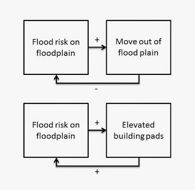
OK, OK, these examples were deliberately selected to be super familiar so you can hopefully understand the concepts more easily. Let's look at some interesting and important examples of system feedback on Earth.Our first example looks at two different feedback loops possible when humans deal with the physical risk of flooding on a floodplain:
The top feedback is negative. High risk of floods leads people to move out of the flood plain, which in turn puts everyone at lower risk of floods. (Floods will still occur, but people won't be at risk.)
However, the lower feedback is positive. In this example, a high risk of floods leads people to create elevated building pads on the floodplain. That saves the building from a flood, but makes flooding more likely on the rest of the flood plain. The more building pads are built, the higher the floodwaters become until eventually it's nearly the same risk on top the building pads!
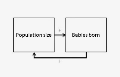
Our final example for this section looks at an issue that was quite concerning to many during the second part of the last century. We'll discuss this feedback more fully in our chapter on population, as it turns out this diagram and feedback loop are overly simplified (though they are essentially true if all other factors are held constant):
Here we see that the larger a population, the more babies are born (again, holding all other factors constant); in turn, the more babies are born, the larger the population becomes.
4. Regions describe areas with common characteristics.
It's a common tendency to generalize things to reduce complexity Geographers have three ways of describing areas of land as regions. A region is an areas that has at least one characteristic in common that is absent from adjacent areas.
Formal regions
A formal region, also known as a uniform region, is an area that has at least one characteristic uniformly throughout. Because of the uniformity of that characteristic, a formal region usually has a clearly defined boundary, or border. (Note that having a boundary isn't what makes it a formal region, it's being a formal region that gives it a clear boundary.) Here are some examples of formal regions:
Florida, shown in outline above, is a formal region because it has one thing in common everywhere inside its border that is not in common with areas outside that boundary: state law. Florida state law is uniform everywhere inside Florida and does not apply outside it. As soon as you cross the border north into Georgia, for example, you are now subject to Georgia state law and not to Florida. Some interesting geographic contrasts exists because of the absolute nature of state boundaries. For instance, Florida and Georgia both raised their minimum age to purchase alcohol from 18 to 19 in 1980. But while Florida raised their minimum age to 21 in 1985, Georgia did not do so until 1986. What do you think some people who were 19 and 20 years old in northern Florida did in 1985 if they wished to purchase alcohol?
Formal regions can overlap or be nested. For instance, Miami-Dade County is a formal region because county law is uniform throughout its area but does not apply outside of its border. We consider this region "nested" because it is completely within Florida, so both county laws and state laws apply. Similarly, Florida is nested within the formal region of the United States. Federal law applies everywhere in Florida and in all other states. In an interesting exception to state law, federal law grants many American Indian reservations sovereignty so state and local laws do not apply there.
Physical formal regions also exist. For instance, the major part of Florida is a peninsula, defined as a piece of land connected to mainland but surrounded by water on three sides. Note that the physical region of the Florida peninsula is smaller than the formal region of the state of Florida, because the "panhandle" is not part of the peninsula, nor are the Florida Keys, which are islands. Note that a clear definition is required for a physical formal region. Islands are easily so defined, but others may be more difficult. For instance, how do we define exactly where a mountain region begins or ends? Unless there is a clearly defined category for inclusion in the region, for example, "areas over 1,000 feet elevation" it's difficult to consider it a formal region as there could be disagreement over its uniformity or its boundaries.
Functional regions
Functional regions are defined by some characteristic or characteristics in common across an area, but not uniformly. Instead, functional regions tend to have a center of the characteristic in question and that characteristic becomes less important, or "fades," with increasing distance from the center. For this reason, functional regions are also called nodal regions because they have a center point, or node.One example of a functional region is the area serviced by an FM radio station. If you're tuning in to a radio station, chances are you're fairly close (within a few tens of miles) of that station's broadcast tower. The farther away you go, the worse the reception, until you just can't tune in anymore. But there's not a line that you cross where reception goes from 100% to 0%. Instead, there is a zone of worsening reception as the station becomes less distinct and fuzzier.
Another example of a functional region is a city. Importantly, note that cities have formal boundaries and the formal region of a city is defined as the areas where the city's laws apply. That is, everywhere inside city limits. But does a city really end at "city limits"? Take a look at this satellite view of Indianapolis, Indiana:
 |
| Map data (c) 2014 Google; Imagery (c) 2014 DigitalGlobe, IndianaMap Framework Data, USDA Farm Service Agency |
The yellow line running down the center of the image is the city limits of Indianapolis. Areas to the west (left side) of the image are inside city limits, while the eastern side (right side) of the image is unincorporated (not part of a city) county land. Does the city's legal limit serve as a good definition for where the city starts or stops? Instead, we might say that this area of what appears to be predominantly farmland is not very much part of the the functional region of the "city of Indianapolis."
Functional regions are a useful way of describing space for characteristics that become more important, or more dominant, towards the center of that space, and less so farther away. Accordingly, functional regions do not usually have a clearly defined boundary, but rather a "fuzzy" boundary where something becomes less and less predominant as one moves away from the center.
Vernacular Regions
The third way geographers define regions is through vernacular regions. Vernacular regions are also called perceptual regions because they are defined by common, everyday use of the general public. That is, people agree the regions exist, but it may be hard to find a formal or functional definition for the region.The classic example of a vernacular region is the American South, or sometimes the South, of the United States. While based on a compass direction, it's not only about that: California is located along the southern US border but it's not Southern, not part of the South, yet many people consider West Virginia to be Southern when it's located north of Arizona and New Mexico. The South is a vernacular region because most Americans agree that such a place exists, but if you ask 100 random Americans to draw a line around it you would probably get 100 different lines. For example, south Florida is not considered by many to be very Southern. Here's a map based on a recent survey asking Americans to identify which states are part of the South:
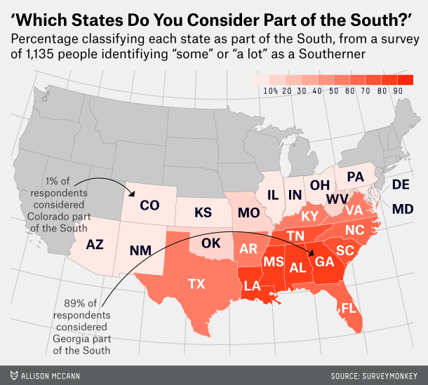 |
| Source: fivethirtyeight, http://fivethirtyeight.com/datalab/which-states-are-in-the-south/ |
Understanding vernacular regions is important for more than just trivia and curiosity. Everyone has a map in their heads, a mental map, composed of their own learning, experiences, and impressions. So when we decide whether we would move out of our current home for a job, or to go to school, we rely on our own impression of those vernacular regions. If you were offered a job or a scholarship in the South, would you consider moving there, or not? People sometimes make decisions based solely on their impressions of a place.
5. Describing places
How do we tell someone about a place? How do you answer the question, "where are you from?" Geographers have three ways of answering that question in addition to the classic shortcut of using a placename, the name given to a particular place on Earth, like "I'm from Providence." If our audience knows where Providence is, the placename is enough.But if they don't know where Providence is, what then? We provide more information, like "it's in Rhode Island," or perhaps "in the Northeastern United States," or even "it's an hour south of Boston and about four hours northeast of New York city." These are examples of relative location, which describes a place's position relative to other places. Relative location is useful for helping us understand the importance of a place's location.
Another way of telling people where Providence is that even the nerdiest of geographers don't use is to reference its mathematical location. The mathematical location of Providence using latitude and longitude is "41.8 degrees north, 71.4 degrees west." While no-one uses those coordinates in everyday conversation, there is a unique set of coordinates for every place on Earth. Mathematical location is used by mapmakers and underlies the computer programs that generate directions to and from places or navigates ships and airplanes.
A final way geographers describe place is more an answer to "what's it like?" than "where is that?" This is to describe a place's site, or the physical and cultural characteristics of a particular place. So we might describe Providence as a medium-sized city; we might describe its climate as cold in the winter with warm, humid summers; we might mention that the Providence River flows through town into Narragansett Bay.
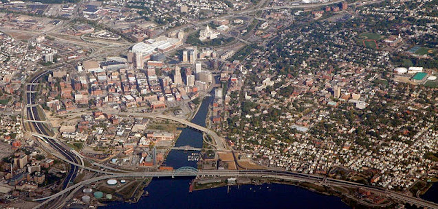 |
| The site of Providence, Rhode Island. Image by Doc Searls, used under CC Attribution 2.0 Generic, source https://www.flickr.com/photos/docsearls/5042563105/ (via WikiMedia Commons) |
6. Cultural Landscapes
The previous section ended with a description of the site of Providence, Rhode Island.
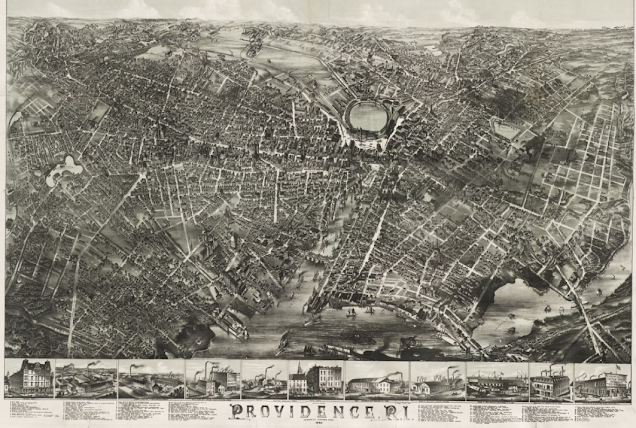
Here's an older view of downtown Providence, from 1882.
 |
| Source: By O.H. Bailey & Co. - Boston Public Library, Norman B. Leventhal Map Center. http://maps.bpl.org/id/10162 |
Note how the scene has changed. Buildings are taller, there are more bridges, the waterfront is more filled in with earth. The first scene shows ships busily moving up the river mouth to docks very close to downtown, and the straightened sides of the river channel were used for more ships to tie up and load or unload their cargo. Those uses are largely absent from the modern city.
Each image shows us a landscape. A river, a bay, land, hills, and vegetation are all there. But even by 1882 the landscape had been extensively modified by human activity. We call any landscape that shows both physical and human signs a cultural landscape. Different cultures make their own cultural landscapes, some unique and some only slightly different than others. Cultural landscapes include our choice of housing, the roads we build (or don't build, choosing instead to travel by boat, foot, or train), the crops we plant or forests we cut down, and even the people within the landscape, including their style of clothing and social customs.
The photo at the main page for geog100.org presents a cultural landscape different from what many students in northwest Washington experience on a daily basis--go back for another look at that image and think about what makes that landscape different from, or similar to, your own. How do people dress? Where do they live and work? How do they get around?
Now imagine what the first Europeans to visit the Providence River would have found. Would they have seen a straightened waterway criss-crossed by bridges? Would there have been roads laid out in a grid fashion? Buildings made of brick? No. But there was a landscape modified by human activity, as the Narragansett people lived there before Europeans ever arrived. Their use of the landscape was unarguably less destructive of natural features but there was still a combination of human activity and the natural world at work to create a particular cultural landscape.
Understanding and appreciating the idea of cultural landscapes is one of the keys to thinking like a geographer. A geographer's imagination allows one to think about what the landscape looked like in times past, how it has changed to look as it does now, and how the choices we make today, whether carefully planned or not, will change the cultural landscape of the future.
Here's a brief example where I show you around the cultural landscape of my neighborhood, White Center, Washington (captions are on since I'm not the most clearly spoken when there are lots of distractions around!):
Last updated September 24, 2022
